
- View
- Nature/Scenic Spots
- Sightseeing
- Experience
- History & Places of Interest
- Nature/Scenic Spots
-
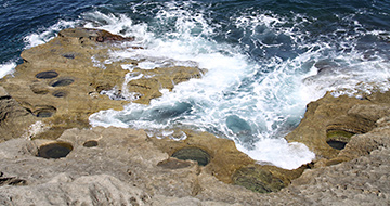 Sea Strange Rocks and Bizarre Stones
A group of marine potholes in Hiranezaki
Thousands of round holes can be seen on the slope of rocks stretching approximately 500m on Hiranezaki Coast, situated to the north of Senkakuwan Bay. This is the largest group of potholes in Japan, formed by the whirl of sea water, and these potholes are designated as Japan's natural monument. Pebble can be seen in the holes, and those pebbles whirl around in the turbulence of waves and accelerate erosion. Hot water is bubbling up from the sea bed offshore, and that is a renowned spot popular for divers.
Aikawa area -
 Sea Strange Rocks and Bizarre Stones
Akagameiwa Rock
Akagameiwa is a big, red stone of iron quartz, which can be seen from a bathing beach in Akagame Kazashima Nagisa Park. The rock has a hollow in the middle, and the shape resembles to parent and child nestling up together. "Once upon a time, when a fisherman in Suizu encountered a turbulent sea, a big turtle appeared, and the fisherman and his boat rode on the turtle's back and returned to the port. The turtle turned into a rock, and villagers named the rock "Akagame". The rock has this folk story, and there is a shrine to enshrine Akagame Myojin god.
Ryotsu area -
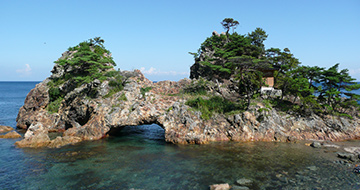
 Strange Rocks and Bizarre Stones
Benkei no Hasamiiwa
Benkei no Hasamiiwa is a peculiar sight located on seashore in Shimoaikawa, along Prefectural Route 45. A wedge-shaped rock is stuck between two giant rocks. Once upon a time, Sado Benkei and his company mountain priests were making their way to Mount Kinpoku for ascetic training, when a demon appeared in an ambush and requested a contest of strength. Sado Benkei threw rocks in the air, and the rocks are said to be thrown onto the beach in Shimoaikawa. A grave of a consummate governor of Sado, Ichizaemon Shizume adjoins the beach.
Aikawa area -
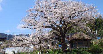 Plants
Cherry Tree of Hojobo
The cherry tree of Hojobo sits in Hamochi Osaki, a place known for the Osaki Soba (buckwheat noodles) Festival. Branches stretch out as if they are cuddling up to the thatched roof house on the site where Hojobo Temple used to be. The tree is said to be 250–260 years old, measuring 21 meters tall and 6.9 meters in circumference at its base. The crown stretches 26 meters both east-to-west and north-to-south. The tree marks the timeline of farmwork, and locals affectionately call it "Hojobo's sowing cherry."
Minami Sado area -
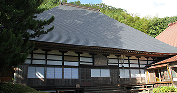 Plants
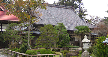
Chokokuji Temple
Founded by Kobo Daishi (Kukai) in 807, Chokokuji Temple is an ancient temple which imitates Hasedera Temple in Yamato (present-day Nara Prefecture). The temple is where Zeami paid a visit after landing on Sado Island, and he mentioned the temple in his book Kintosho (Writings of the Golden Isle). The temple is also known as a temple of flowers, including peony. Chokokuji Temple owns a large number of cultural assets which shadow living history, varying from three Eleven-Headed Kannon Statues (National Important Cultural Properties), to statues of Kongo Rikishi (two wrath-filled guardians of the Buddha) made in the Heian Period (10th-12th centuries), as well as Gochido Hall. Within the grounds, there are also three cedar trees and Japanese Umbrella-pine trees, both of which belong to Niigata Prefecture's Natural Monuments.
Kuninaka area -
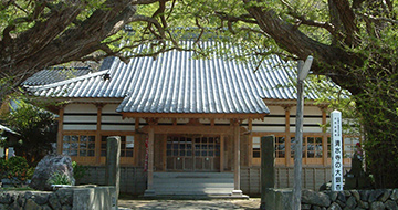
 Plants
Daianji Temple
Daianji was established in 1606 by Nagayasu Okubo, the first Commissioner of Sado. A long, beautifully cobbled path leads up to the Sanmon gate, and the main hall features the temple crest of three leaves of hollyhock in a circle. The temple houses a memorial tower built by Nagayasu Okubo prior to his death, and a memorial tower for Hikozaemon Kawamura who was involved in the early-stage development of the Sado gold and silver mines. Both towers are National Historic Sites. This temple also holds the burial grounds for officials who served the Sado Commissioner's Office. A spectacular Machilus thunbergii (bay tree) grove, a Sado Natural Monument, stands behind the graveyard. Drastic urbanization due to the development of the mines significantly changed the landscape of the Aikawa area. Still, groves within the grounds of temples and shrines retain their native vegetation. Many plants such as the giant Machilus thunbergii, camellia and Euonymus japonicus (Japanese spindle) grow in the dense natural woodland of Daianji Temple.
Aikawa area -
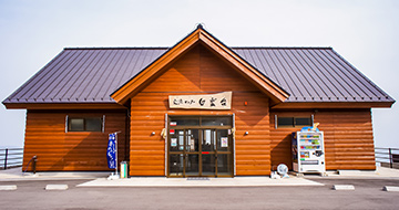 Mountains
Exchange Centre Hakuundai
Hakuundai is a lodge-style building standing at about 850 metres above sea level. The viewing terrace offers a stunning panoramic view across Sado, including Ryotsu Bay, Kuninaka Plain and Ogi Peninsula. At the souvenir shop inside the building, you will find Sado specialties, such as "Okesa persimmon butter", "fig jam", and "wild grape wine". Curry over rice with the Island's black Berkshire pork, and soft ice cream made from fresh cream are special menu items at the light meal corner. Hakuundai is closed for winter as Osado Skyline will be closed due to snow.
Kuninaka area -
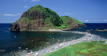 Sea Strange Rocks and Bizarre Stones
Futatsugame
Futatsugame resembles two turtles nestling closely and the scenery changes according to the tide. The water around Futatsugame is the clearest in Sado, and Futatsugame Bathing Beach has been selected as one of the Top 100 Sea-Bathing Spots in Japan. Futatsugame is also listed with two stars on the Michelin Green Guide, along with Onogame.
Ryotsu area -
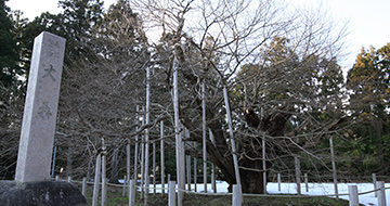 Plants
Giant Aino Mulberry in Hayoshi
As an island of silk-farming using Aino mulberry leaves, Sado used to boast the top sericulture industry in Niigata Prefecture. This giant, ancient Aino mulberry tree is estimated to be 1300 years old, measuring 9 meters tall and 5.2 meters around the base. The trunk divides into four branches, and the crown spreads 18 meters. Hayoshi's Aino mulberry tree is one of the three great mulberry trees in Japan, together with one at Ebisu Shrine in Otaru City, Hokkaido, and another in Usune, Numata City, Gunma Prefecture.
Ryotsu area -
 Plants
Giant Ginkgo in Niibo Ono
This giant ginkgo stretches its branches in the garden of a house in front of Seisuiji Temple, and locals affectionately call it "Seisuiji's Giant Ginkgo." Ginkgo trees have either male or female flowers, and this giant ginkgo is a male. An estimated 1,000-years old, leaves sprout every spring and turn golden yellow in autumn. Measuring 29.5 meters tall and 16.7 meters in circumference at the base, the crown spreads approximately 19 meters both east-to-west and north-to-south.
Kuninaka area -
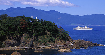
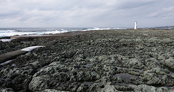
 Lighthouses
Hajikizaki Lighthouse
Hajikizaki Lighthouse is an octagonal lighthouse located at Hajikizaki in the Washizaki area, the northernmost part of Sado. The lighthouse is known as the location of the film: "The Lighthouse," or "Times of Joy and Sorrow" (Japanese title: Yorokobi mo kanashimi mo ikutoshitsuki), which tells the story of a lighthouse keeper and his wife. Hajikizaki Lighthouse was built in 1919. Since then, it has been responsible for assisting the safe passage of all vessels for almost 100 years.
Ryotsu area -
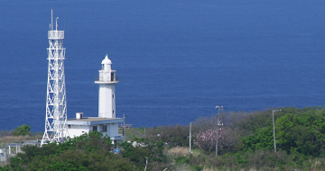
 Lighthouses
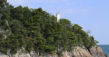
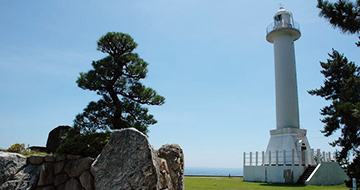
Himesaki Lighthouse
As the first lighthouse built in Sado, its light first flashed in 1895. Himesaki Lighthouse is the oldest, intact iron lighthouse in Japan. As a historical and cultural asset, it has been selected as one of the Top 100 Lighthouses in the World. The elegant, white appearance beautifully contrasts with the blue sky. The nearby Himesaki Lighthouse Visitor Centre displays valuable materials.
Ryotsu area -
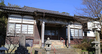
 Plants
Ishina Seisuiji Temple
According to the temple's book of origin, it was founded in 807. The spring bubbling up by the sanmon gate (the first gate to the temple) is the miraculous water of the inner shrine, Dantokusan, which is also the sacred mountain where monks practise mokujiki. 190 years after Mokujiki Tansei (a Buddhist monk enlightened in Sado around 1600), Mokujiki Gyodo, a nomadic monk, visited Sado in 1781-1789, and reconstructed a Buddhist hall in the area where Mokujiki Tansei practised ascetic disciplines. There, statues of Seated Yakushinyorai (Bhaisajyaguru: the Buddha of healing and medicine) and Standing Jizo (the guardian deity of children) were put up. The big ginkgo tree is Sado City's designated natural monument, and it is worshipped as a ginkgo of fertility, or a spiritual tree with healing effects for gastroenteropathy.
Aikawa area -
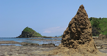
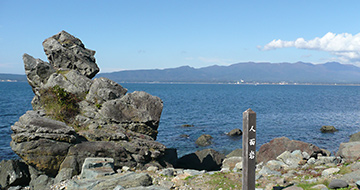 Strange Rocks and Bizarre Stones
Jinmeniwa (Tateiwa)
Jinmeniwa is an oddly-shaped rock approximately 10m high, standing on the Koshi no Nagahama seashore stretching from Mano to Ogi. The rock is made of green-coloured andesite, and it is called "Jinmeniwa (human face rock), as it resembles to a person looking into far distance. Jinmeniwa is a popular location to take photos with the background of Mano Bay, and the rock stands out from all of the other numerous unique rock formations in Sado.
Kuninaka area -
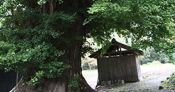
 Plants
Jissoji Temple
It is said that Nichiren Shonin, founder of Nichiren School of Buddhism exiled to Sado, stood and chanted mantra on this hill every morning, after forced to live in Ichinosawa. The precinct is scattered with a bronze statue of Nichiren, praying to the rising sun whilst thinking of his parents at home in Awa (present-day Chiba Prefecture), Kesagake no Matsu (a pine tree which he hang his monastic robe on), a spring with which he rinsed his hands, and so on. Also, "Sanko no Sugi", a gigantic cedar tree over 1,000 years old (Sado City's Designated Natural Monument) stretches its branches.
Kuninaka area -
 Lighthouses
Jogahana Lighthouse
Driving down to the south on Sado's Ring Road, you can see Jogahana Cape in the Noura area. A white tip of the Jogahana Lighthouse can bee seen between the trees on a rocky mountain, above a tunnel on the small cape. It is a small lighthouse approx. 11m high, and it flashed its first light in 1966. There is no road connection to the lighthouse. To get to the lighthouse, please walk for about five minutes along a narrow path from the point with a sign at the side of a house in the hamlet of Noura.
Ryotsu area -
 Plants
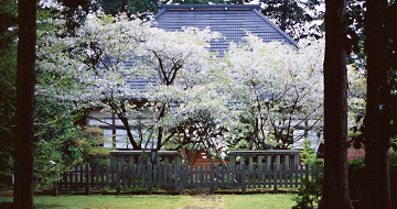
Kaichoji Temple
Kaichoji Temple is an old temple of Soto Zen School located in the middle of the hill leading down to Yajima and Kyojima. The two trees of Goshozakura variety of cherry blossoms in front of the main hall are said to have been planted by Emperor Juntoku himself. Each branch produces a blend of single- and multi-layered white flowers, which are very rare, and the cherry trees at Kaichoji Temple are designated as National Natural Monument. Cherry flowers are in bloom from late April until early May.
Minami Sado area -
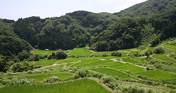
Katanoo Terraced Rice Fields
In a mountainous area facing the sea, rice terraces in various sizes stretch out for 200,000 square meters. The large temperature gap between day and night at this height, the clear water streaming from the mountains, and the love of people in Katanoo make for delicious rice. Among other things, Katanoo boasts of its rich nature, once inhabited by the last wild Toki (crested ibis). People in Katanoo are continuously working on creating a biotope, and growing organic and reduced-agrochemical rice.
Ryotsu area -
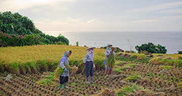
Kitakatabe Terraced Rice Fields
This raised beach rich in ocean breezes is terraced with a series of rice paddies, and the taste of rice nurtured in the mineral-laden sea air has an established reputation. Cold water streaming down from the backdrop of mountains also works to maximize the rice's flavor. A famous folk tale "Tsuru no Ongaeshi" (The Crane's Gratitude) originated from a piece of Kitakatabe folklore called, "Tsuru Nyobo" (The Crane Wife). Villagers lovingly grow rice here in the north of Sado, where simple folk tales have been passed down through generations.
Aikawa area -
 Lighthouses
Konosehana Lighthouse
Konose Cape is located closest to Echigo (Niigata) in Sado. The area used to flourish as a gateway to Sado in ancient times, and is also known as a landing point of Emperor Juntoku and Nichiren Shonin (Buddhist monk), both of whom were exiled to Sado. Konosehana Lighthouse stands within Matsugasaki History Park, a vast free campsite. Konosebana Lighthouse flashed its first light in 1952. Since then, Konosebana Lighthouse has been responsible for assisting the safe passage of all vessels in the straits between Sado and Niigata (aka Essa Straits).
Ryotsu area -
 Waterfalls, Ponds and the Lake
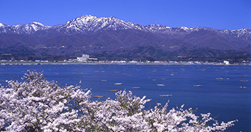
Lake Kamo
Lake Kamo, with approximately 17km of circumferences, is the largest one in Niigata Prefecture. Originally, the lake was freshwater, but it was cut open to the sea in the Meiji Period (1868-1912) in order to prevent flooding, and became a brackish lake. There is a promenade and a cycle path along the lake, and you can enjoy scenery with atmosphere, which was depicted in the poetry. In addition, oysters have been farmed in Lake Kamo since 1932.
Ryotsu area、Kuninaka area -
 Strange Rocks and Bizarre Stones
Manjojiki
Manjojiki," located near the Sawasaki Coast, is a flat area of land (uplifted wave-cut platform) created by an earthquake that raised the seafloor. It is a good place for collecting rock seaweed and is also important for local industry. When the weather is good, it is one of the most popular places to take pictures because it looks like the "Salar de Uyuni".
Minami Sado area -
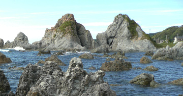 Strange Rocks and Bizarre Stones
Meotoiwa Rocks
Meotoiwa is two gigantic rocks considered to originate from a Japan's creation myth in an ancient book "Kojiki (Record of Ancient Matters)". On the right hand side is "husband" rock (22.6 meters high), and on the left hand side is "wife" rock (23.1 meters high). The rocks stands nestling up together, lapped by waves of Nanaura Coast. The rocks are said to bring luck in finding a partner. The surrounding area is spotted with rocky shores, such as Nekoiwa (Cat Rock) and Hokakeiwa (Sailing Rock) , which are, in Sado, said to originate from a Japan's creation myth.
Aikawa area -
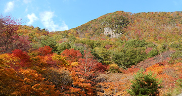 Mountains Plants
Momijiyama
Sansuke and Okiku, who are reputed to started rice cultivation in Sado, are enshrined at the two peaks of Mt. Ogamiyama and Mt. Megumiyama in the middle of the Kosado area. The southern slopes are known as a spot to see beautiful autumn foliage, and lead to Momijiyama Park. You can walk around the park on a promenade and enjoy views from a viewing deck in the park.
Kuninaka area -
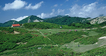 Mountains Plants
Mount Donden
Mount Donden, officially named Mt Tadaramine, is the whole highland area including three mountains above 900m. As the nickname,originated from the word "donden", which means roundtop mountain, indicates, Mount Donden is located at the heart of steep Osado Mountains and solely appears with modest inclines among the mountains. The surrounding area is a treasury of alpine plants and wildflowers. Mount Donden is one of the new Top 100 Mountains and TOP 100 Mountains of Flowers in Japan and many trekkers visit there from April towards early Summer.
Ryotsu area -
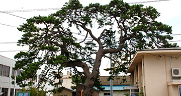 Plants
Murasame no Matsu (rain-showered pine)
Within the grounds of Sado Japan Coast Guard Station, a Japanese black pine tree with beautifully shaped branches stands nineteen metres tall, and has a girth of six metres. It used to be a navigational aid for maritime pilots at sea, and is mentioned in the folk song, "Ryotsu Jinku". Murasame no Matsu used to be called "Otabisho no Matsu" (a pine tree at the midway resting point of a god during a procession), or "Gobansho no Matsu" (a pine tree at a port observation post). Koyo Ozaki, a novelist who visited Sado in the Meiji times (1868-1912), thought the tree getting splashed by waves resembled the wetness of getting caught in a shower of rain (called "murasame" in Japanese). The tree's name is derived from this episode. Murasame no Matsu is a Niigata Prefecture Natural Monument.
Ryotsu area -
 Sea Strange Rocks and Bizarre Stones
Nagate Peninsula
Located in the heart of Nanaura Kaigan, the peninsula is a picturesque scenery made up an endless flat rocky surface. The uniqueness of the elevated coast has earned it the designation of ‘Sado-Yahiko-Yoneyama Semi-National Park’. The shoreline is dotted with ever-changing strangely shaped rocks which contributes to the beauty of the coast. This spot is popular for gathering shellfish, swimming, snorkeling, and fishing and is also known to witness magnificent views of the sun setting into the ocean.
Aikawa area -
 Sea Strange Rocks and Bizarre Stones
Ogi Coast
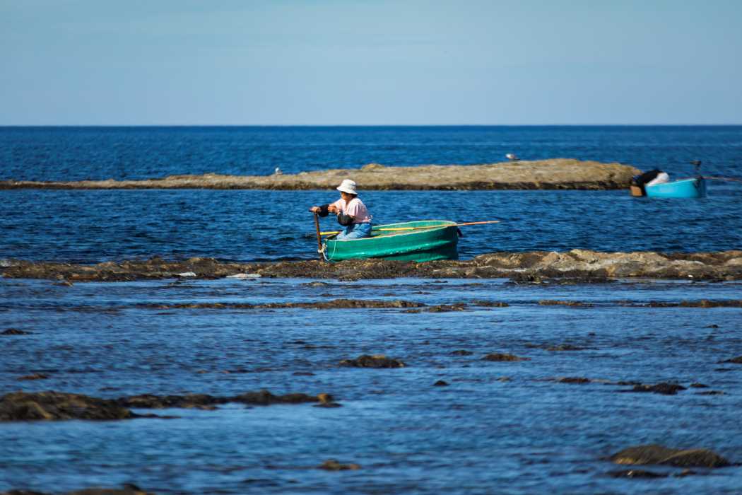
The Ogi Coast stretches about 16 km from Shiroyamadai in Ogi to Mikoiwa in Sawasaki. The varied coastline, formed by volcanic activity, is designated as a Japan National Monument and Scenic Site under the name of Sado Ogi Coast. The area is home to many scenic spots, such as Yajima and Kyojima, Nansenkyo, and a plateau of pillow lava in Sawasaki. The Ogi Coast is also known for its tub-boat fishing, on which people can get around rocky shores easily.
Minami Sado area -

Ogura Senmaida (terraced rice fields)
Small rice fields are located side-by-side on a slope of a mountain close to Ogura Dam, along Prefectural Route 181 stretching through Hatano to Oda. Ogura Senmaida is Sado's representative terraced rice fields, and these fields are said to be cultivated to feed an increasing population as a result of the thriving gold mine in the Edo Period (1603-1867). Although the terraced rice fields were once on the verge of being set aside or abandoned, local people now work to manage and maintain the fields by introducing field ownership system from around 2000.
Kuninaka area -
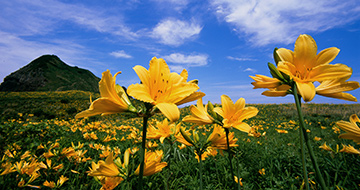 Plants Strange Rocks and Bizarre Stones
Onogame
Onogame is a 167-meter high monolith projecting into the sea, and that is a sight to see. The giant rock gained two stars in the Michelin Green Guide Japon. The surrounding area is where amur daylily (Tobishima kanzo) grows in clumps, one million flowers in 500 thousand amur daylily. Many people visit there when yellow flowers come into full bloom. The blooming season is from late May until early June. Every year, the Sado Kanzo Festival is held on the second Sunday of June, when Onidaiko (deity mask dance native to Sado) and folk songs are performed.
Ryotsu area